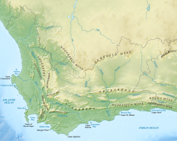
File:Western Cape Topology.jpg
外观

本预览的尺寸:750 × 599像素。 其他分辨率:300 × 240像素 | 601 × 480像素 | 961 × 768像素 | 1,280 × 1,023像素 | 1,498 × 1,197像素。
原始文件 (1,498 × 1,197像素,文件大小:930 KB,MIME类型:image/jpeg)
文件历史
点击某个日期/时间查看对应时刻的文件。
| 日期/时间 | 缩略图 | 大小 | 用户 | 备注 | |
|---|---|---|---|---|---|
| 当前 | 2016年3月10日 (四) 06:35 |  | 1,498 × 1,197(930 KB) | Oggmus | The central area had been incorrectly labeled the "Central Escarpment" when it should have been "Central Plateau" |
| 2015年6月5日 (五) 18:01 |  | 8,000 × 6,364(9.65 MB) | Oggmus | Made the escarpment diagrammatically more obvious than just a blue line | |
| 2014年5月24日 (六) 10:34 |  | 7,326 × 5,838(3.07 MB) | Oggmus | User created page with UploadWizard |
文件用途
以下页面使用本文件:
全域文件用途
以下其他wiki使用此文件:
- cs.wikipedia.org上的用途
- de.wikipedia.org上的用途
- en.wikipedia.org上的用途
- es.wikipedia.org上的用途
- nl.wikipedia.org上的用途
- pl.wikipedia.org上的用途
- ru.wikipedia.org上的用途
- sw.wikipedia.org上的用途


