原始檔案 (800 × 682 像素,檔案大小:181 KB,MIME 類型:image/jpeg)
This image was copied from wikipedia:zh. The original description was:
- 您可以自由:
- 分享 – 複製、發佈和傳播本作品
- 重新修改 – 創作演繹作品
- 惟需遵照下列條件:
- 姓名標示 – 您必須指名出正確的製作者,和提供授權條款的連結,以及表示是否有對內容上做出變更。您可以用任何合理的方式來行動,但不得以任何方式表明授權條款是對您許可或是由您所使用。
- 相同方式分享 – If you alter, transform, or build upon this work, you must distribute the resulting work under the same license as the original.
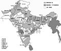
https://creativecommons.org/licenses/by-sa/1.0CC BY-SA 1.0 Creative Commons Attribution-Share Alike 1.0 truetrue1939年的印度次大陆政治地图
| date/time |
username |
resolution |
size |
edit summary
|
| 2006年3月30日 (四) 09:55 |
Kallgan |
800×682 |
181 KB |
{{PD-self}} {{GFDL}} 1939年的印度次大陆政治地图
|
檔案歷史
點選日期/時間以檢視該時間的檔案版本。
| 日期/時間 | 縮圖 | 尺寸 | 使用者 | 備註 |
|---|
| 目前 | 2008年2月1日 (五) 01:28 |  | 800 × 682(181 KB) | Shizhao | This image was copied from wikipedia:zh. The original description was: {{cc-by-sa}} 1939年的印度次大陆政治地图 {| border="1" ! date/time || username || resolution || size || edit summary |---- | 2006年3月30日 (四) 09:55 || Kallga |
檔案用途
此檔案中包含其他資訊,這些資訊可能是由數位相機或掃描器在建立或數位化過程中所新增的。若檔案自原始狀態已被修改,一些詳細資料可能無法完整反映出已修改的檔案。


