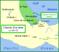
File:Olmec Heartland Overview 4.svg
外观

此SVG文件的PNG预览的大小:800 × 570像素。 其他分辨率:320 × 228像素 | 640 × 456像素 | 1,024 × 729像素 | 1,280 × 911像素 | 2,560 × 1,823像素 | 1,788 × 1,273像素。
原始文件 (SVG文件,尺寸为1,788 × 1,273像素,文件大小:257 KB)
文件历史
点击某个日期/时间查看对应时刻的文件。
| 日期/时间 | 缩略图 | 大小 | 用户 | 备注 | |
|---|---|---|---|---|---|
| 当前 | 2007年12月30日 (日) 01:03 |  | 1,788 × 1,273(257 KB) | Madman2001 | Added two sites: Cobata and Cascajal, moved Llano del Jicaro west of Laguna de los Cerros, based on information in Pool. |
| 2007年12月7日 (五) 18:52 |  | 1,788 × 1,273(255 KB) | Madman2001 | A map of the Olmec heartland. The yellow sites are known villages and towns. The smaller red dots mark locations where artifacts or art have been found unassociated with habitation. The river courses and shorelines are modern, |
文件用途
以下页面使用本文件:
全域文件用途
以下其他wiki使用此文件:
- af.wikipedia.org上的用途
- ar.wikipedia.org上的用途
- bn.wikipedia.org上的用途
- ca.wikipedia.org上的用途
- de.wikipedia.org上的用途
- el.wikipedia.org上的用途
- en.wikipedia.org上的用途
- Olmecs
- La Venta
- Mesoamerican chronology
- Cradle of civilization
- Portal:Geography
- Tres Zapotes
- User talk:Madman2001
- San Lorenzo Tenochtitlán
- El Azuzul
- Portal:North America/Selected picture
- Portal:Maps/Selected picture
- Olmec heartland
- Talk:Olmec heartland
- El Manatí
- Laguna de los Cerros
- Las Limas Monument 1
- Wikipedia:Wikipedia Signpost/2007-12-17/Features and admins
- Wikipedia:Featured pictures thumbs/09
- San Andrés (Mesoamerican site)
- Wikipedia:Featured picture candidates/December-2007
- Wikipedia:Featured picture candidates/Map of the Olmec Heartland
- San Martín Pajapan Monument 1
- Portal:Maps/Selected picture/34
- Wikipedia:Featured pictures/Diagrams, drawings, and maps/Maps
- The Wrestler (sculpture)
- Wikipedia:Wikipedia Signpost/2007-12-17/SPV
- Portal:North America/Selected picture/10
- La Joya (archaeological site)
- List of archaeological sites in Veracruz
- User:Minervasabia/sandbox
- Wikipedia:Picture of the day/May 2015
- Template:POTD/2015-05-30
- Wikipedia:Main Page history/2015 May 30
- Portal:Civilizations
- Portal:Geography/Selected picture
- Wikipedia:Wikipedia Signpost/Single/2007-12-17
- en.wikibooks.org上的用途
- eo.wikipedia.org上的用途
- es.wikipedia.org上的用途
- eu.wikipedia.org上的用途
查看此文件的更多全域用途。


